Category Archives: Uncategorized

Historic dribble

Locals welcome the first water to reach Kern County from the State Water Project in the California Aqueduct, 1968. SOURCE: Kern County Water Agency

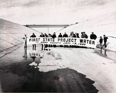
I found this photo on the Kern County Water Agency’s website.

A truly historic day that ushered in an era of water plenty, at least for a few decades.

By 1982 the love affair with large water projects was over and California voters rejected one of the final pieces of the State Water Project, the peripheral canal. It would have taken water from the Sacramento river out of the delta to pumps in Tracy.

Theoretically, that could have avoided problems with endangered species such as the delta smelt and salmon. (There was another piece known as the San Luis drain that theoretically could have avoided salinity issues now plaguing Westlands Water District, but that’s another story).

Anyhow, I thought this photo was cool.

More old maps and the Kern River

Click here to see an 1888 map of the Kern “Delta,” courtesy of the Library of Congress.

You can zoom in and scoot around the map to see the different features more clearly. It looks like the Southern Pacific Railroad was either already completed, or about to be, through Bakersfield.

You can see the different ranches including Bellevue, McClung, Greenfields, Rosedale and more. A number of canals still in use today are also already on this map, including the Beardsley. And the Kern Lake hadn’t yet been dried up.

This map shows a full Kern Lake south of Bakersfield and a number of huge ranches.
This 1888 map shows a full Kern Lake south of Bakersfield and a number of huge ranches.

Compare that to this 1897 map created by the Kern County Land Company, also courtesy of the Library of Congress.


Not even 10 years later, the Kern Lake is gone and most of the ranches are now owned by Kern County Land Company, which renamed them “colonies” and tried to sell them off section by section to incoming homesteaders. Problem was, as I discovered in some old reports by an undercover investigator, the Land Company took all the water (but that’s a later post).

This 1897 map shows dry fields where the Kern Lake used to be and huge swaths of land are owned by Kern County Land Company.