Deprecated: Function WP_Dependencies->add_data() was called with an argument that is deprecated since version 6.9.0! IE conditional comments are ignored by all supported browsers. in /sites/loishenry.com/web/wp-includes/functions.php on line 6131
By LOIS HENRY, The Bakersfield Californian lhenry@bakersfield.com
Indulge me while I share a fascinating fragment of Kern County history. And, wouldn’t ya know, it has to do with water, sort of.
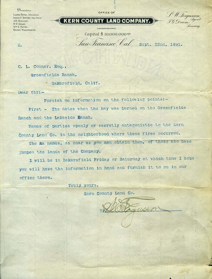
Letter from Kern County Land Co. superintendent S. Ferguson seeking help to find the culprits who burned several stacks of hay on Land Company farms in 1891.
As anyone who’s read my columns knows, I love any and all info related to the Kern River.
So, when Kern County Museum Curator Lori Wear told me last year she was getting a cache of old documents from Castle & Cooke, I was all ears.
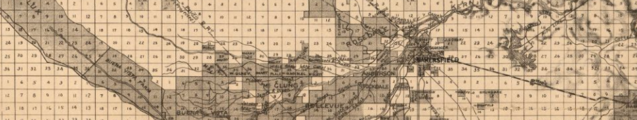
In case you don’t know, Castle & Cooke is the descendant company of Tenneco West, which was the descendant of the Kern County Land Co. And no two entities were more intertwined than the Kern River and the Kern County Land Co.
Yes! I told Wear, lemme know what you find.
She and her staff are still going through the massive document trove, but Wear alerted me to one shiny gem that caught her eye. It’s a series of letters from 1891 about the hunt for desperate criminals marauding the countryside burning hay stacks. Not just any hay stacks but those belonging to Kern County Land Co.
The letters are between the Land Company and a private detective firm in San Francisco.
First, the letters are a wonderful peek into Kern County life at the turn of the last century. Second, and more importantly, they clearly show a level of animosity and intrigue you just won’t find in textbooks.
In mid- and late-August 1891, 10 hay stacks were torched on two properties owned by the Land Company.
Why is that a big deal?
Hay stacks back then were enormous. And without a store of hay, the Land Company couldn’t feed its livestock. That’s money on the hoof.
Aside from that, the Land Company was ever vigilant against disgruntled settlers and others unhappy with how much land — and water rights — the company was gobbling up.
The Land Company’s response to these hay burners was quick and decisive. But, interestingly, not local.
If the Land Company did call local authorities, it didn’t give them much time to solve the case.
About a month after its stacks were torched on Aug. 16 and Aug. 20, 1891, the Harry N. Morse detective agency in San Francisco already had a man on the ground in Fresno preparing to infiltrate the hay arsonist’s ranks.
Morse was a legendary Bay Area lawman known as the “bloodhound of the far west.”
A Land Company boss, S.W. Ferguson, had discovered the names of about half a dozen locals who he believed might be the hay torching culprits. That included “Old man Emerson of the Paletta Ranch,” according to a letter he sent to Morse’s agent, known only as “Operative H.H.”
“Emerson was at one time arrested at the instigation of the Company for cutting water pipes and was in jail for a while on account of this,” Ferguson wrote.
See? It all comes back to the water.
Anyhow, the hay burning was taken extremely seriously by Ferguson who not only wanted to know who burned the hay, but also anyone who had been “… openly or secretly antagonistic to the Kern County Land Co.”
According to Operative H.H.’s reports, he too, was all in.
In his first report from Fresno, H.H. mentions how he and his wife, yes, his wife, had traveled by train from San Francisco and went about getting a wagon, team of horses and camping gear. Not too expensive, nor too cheap looking.
After haggling over the price of horses and covering the wagon himself rather than pay the “exorbitant” price of $15 for stable hands to do it, H.H. and his wife got underway to Bakersfield on Sept. 27, 1891.
Three days later, they arrived in Bakersfield.
“We put up at the Arlington Hotel. We did not care to go to a first class hotel, as we wished to avoid suspicion, and we had the appearance of first-class ‘hay-seeds,’ and not wishing to change our appearance, we concluded to stop at a second class hotel,” H.H. writes in a report dated Sept. 30, 1891. (His reports are all type written, by the way, so, he must have squirreled away a typewriter among his hay seed trappings.)
H.H.’s next report is dated Oct. 4, 1891.
He spends some time roaming around town asking about land for sale and gets some good intel via a time honored technique: “I have found that by the use of some stimulants in the shape of beer, they loosen up considerably.”
He also lets the locals know he’s not a fan of the Kern County Land Co. He meets a man named Charles Scribner, who has connections to a real estate agent named Mr. Maude (likely A.C. Maude, who also dabbled in insurance and owned the weekly Californian newspaper for a time).
Scribner joins in the Land Company bashing, H.H. reports.
“… he frequently alluded to the Land Company as monopolists, and some very endearing terms were used by him against the Land Company. He also said that the Company had ‘spotters’ around, and if there was anyone in town looking for land these ‘spotters’ would inform the person that he would get swindled if he purchased from him, or Maude, or anyone but the Land Company.
“Mr. Scribner said that the Land Company would do anything to dispose of its worthless land.”
H.H. does meet with Mr. Maude, who warns him against bad mouthing the Land Company, which controls the water and could make things “very bad for me.”
H.H.’s next report goes even deeper into dark history of land and water in Kern.
But I’ve run out of room so you’ll have to check back next week to hear how it ends.
Ancient rock art evokes mystery, reverence – even some controversy
LINK to original article: http://www.bakersfield.com/entertainment/ancient-rock-art-evokes-mystery-reverence—even-some/article_999b8a43-d497-592c-98a5-e72683d714b1.html
BY LOIS HENRY lhenry@bakersfield.com
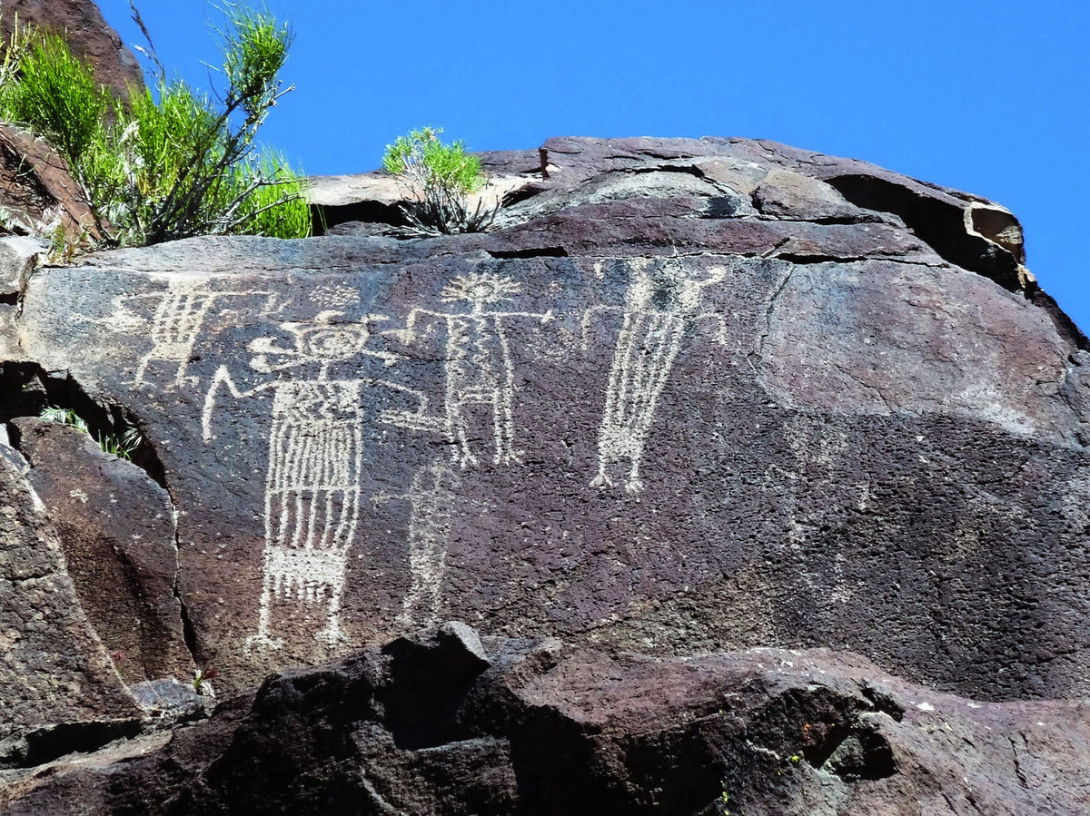
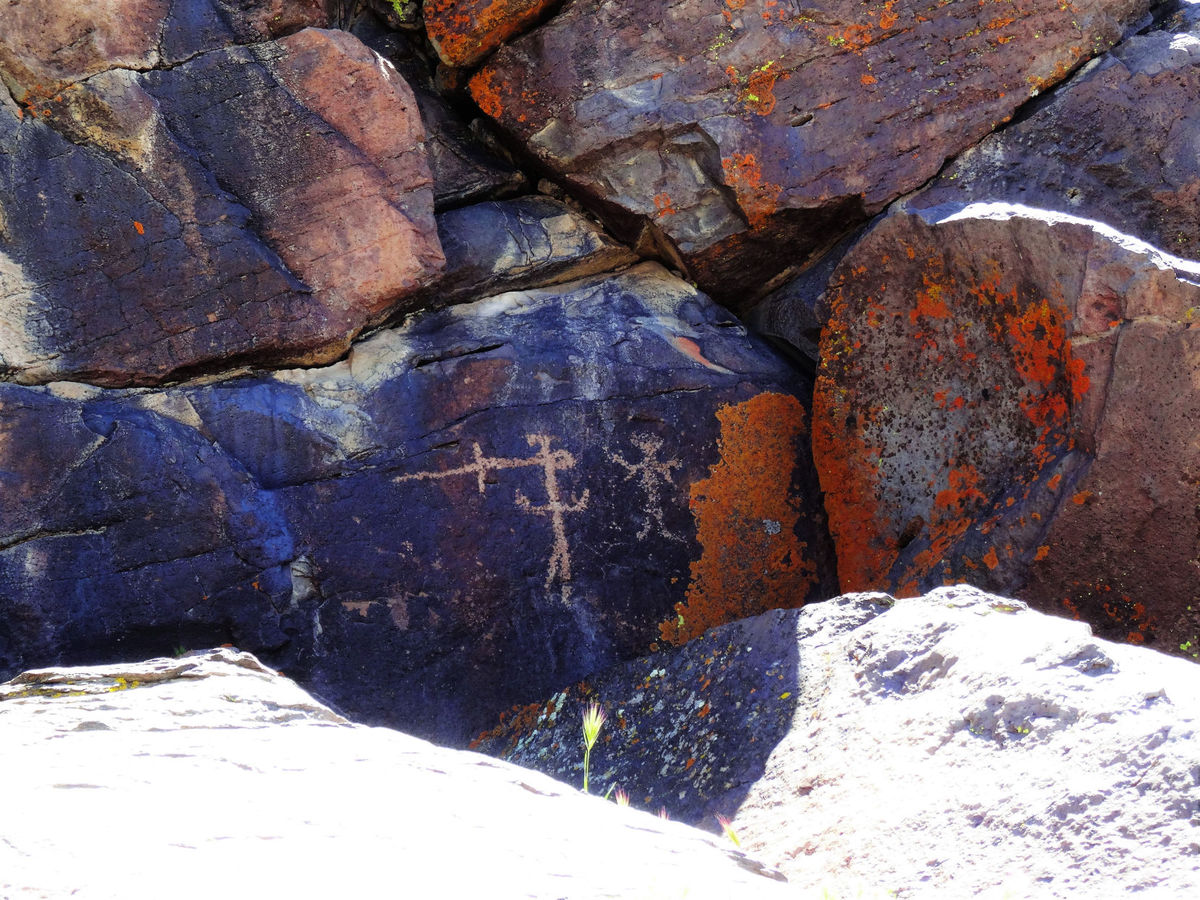
Experts theorize these figures, found throughout the canyon, may be shaman figures.
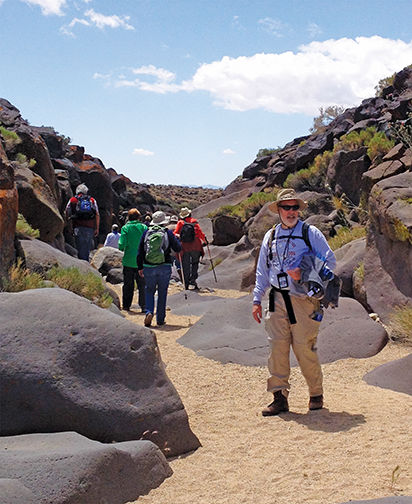
I’ve toured the Little Petroglyph Canyon on the China Lake Navy base twice now.
Both times, I’ve had the same question as I wandered along the sandy floor looking up at countless images painstakingly chipped into the rocky walls:
Why?
The petroglyphs, considered the largest concentration of Native American rock art in the Western Hemisphere, were carved thousands of years ago.
Some may be 6,000 years old. Others are even older — dating back 10,000, perhaps even 15,000 years.
But certainly it was before electricity and takeout food.
My point is that life was tough back then. You had to expend a lot of energy just to survive.
So why would people take time away from finding food and shelter to make thousands upon thousands of cryptic images on rocks?
The fun and kind of frustrating part about the tour is no one gives you an answer.
Tours of Little Petroglyph Canyon
Because not only do we not know when the petroglyphs were made, we don’t know exactly who made them.
“The ancient ones” is the only description given during an orientation film at the first stop tour guests make, in Ridgecrest at the Maturango Museum, which hosts the tours.
According to archeologists, the Paiute-Shoshone people settled in the Coso Mountain area about 800 years ago and likely contributed to the rock art.
But scholars argue over whether the majority of the images predate the Paiute-Shoshone.
Either way, current tribal members consider the art sacred and an important part of their heritage.
The bigger mystery, to me, is what the images meant to those who made them.
Early Navy scientists left their own petroglyphs when China Lake was established in the 1940s.
Even the seemingly self-explanatory carvings, such as bighorn sheep, probably meant more than what they seem on the surface, according to scholars.
The sheep, which used to be prolific in the area, are carved on nearly every surface in the canyon.
Some are clearly being speared, so perhaps those markings depict a recent hunt or wishes for a good hunt.
Others are just there, repeated over and over, leading some scholars to theorize they were spirit animals, possibly associated with water or rain.
Which is interesting because the climate changed in that area dramatically between 12,000 and 700 years ago, going from a lush region with huge lakes (China Lake) to the desert we know today.
So if the petroglyphs were made in the more distant past, those artists were reflecting a very different world, putting their meaning even further out of reach.
People who study these things believe the canyon was a religious site and that shaman or those on spirit quests made the images. Though, again, that’s up for debate.
Some images are easily recognizable: the sheep, antelope, weapons, stick-figure humans.
Others are really mysterious, especially the human-like images that scholars say are shaman figures.
Those have long, rectangular bodies filled with geometric designs and bird claw feet sticking out the bottom.
Their heads are sometimes just swirls or seem to be erupting in flames or aren’t heads at all but a pair of eyeballs on the shoulders.
Some appear to be holding daggers. One looks as if it’s stirring a large pot.
Were they depictions of dreams? Visions? Were they meant to convey a ritual or a final step in some kind of training?
At first, they seem fun, whimsical. But the more you look at them, the eerier they become. You get the feeling they were never meant for public consumption.
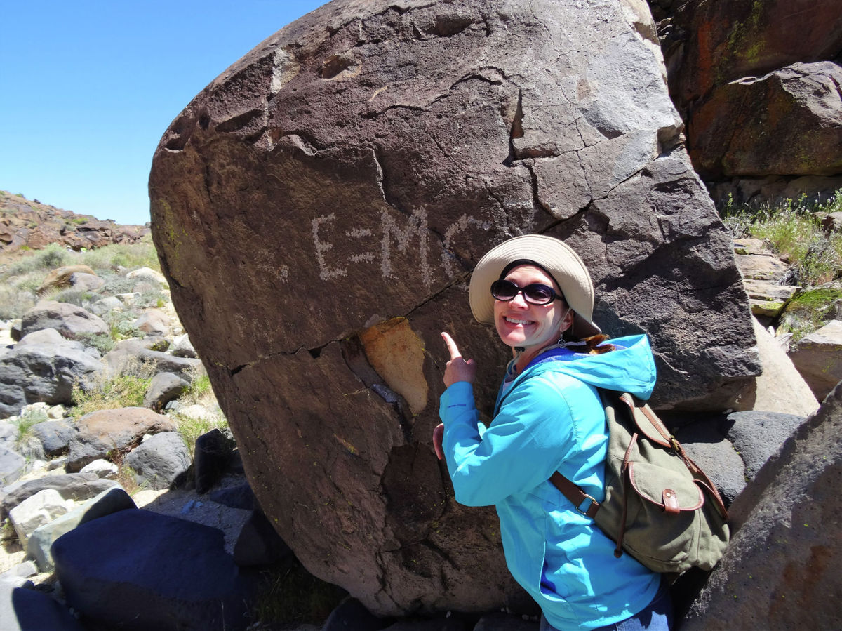
None of the petroglyphs appears haphazard, as if doodled out of boredom. (I’m not counting the more recent additions such as “J.P.” or “E=MC2”; those are just vandalism.)
The ancient petroglyphs are very detailed and clearly took time to make.
One petroglyph appears to depict one figure sticking a knife in another figure’s head. Depiction of war?
Regardless of their specific meanings, I suppose what the petroglyphs tell us in general is that artistic expression has always been a vital part of human existence no matter how hard that existence might have been.
At least that’s my very unscholarly take.
Rock art: overexposed, underappreciated?
Though the Paiute-Shoshone people haven’t objected to museum-led tours of the petroglyphs, the recent Petroglyph Festival in Ridgecrest has created some bad feelings.
The festival is the latest attempt by the City of Ridgecrest to boost its economy outside of the Naval Air Weapons Station China Lake, the town’s main employer.
The city has long billed itself as the gateway to Death Valley and has had a trickle of tourism from that. But mostly pass through.
A couple of years ago, it tried a balloon festival. High winds wreaked havoc on that idea, and the balloons.
Then in 2014, city officials held the first petroglyph festival, a joint effort between the Ridgecrest Area Convention and Visitors Bureau and the Maturango Museum.
It was a hit.
Up to 15,000 people flocked to the desert town over the two days of the event, held in early November. (This year’s festival will be Nov. 5-6, http://rpfestival.com/.)
But many Paiute-Shoshone were dismayed that an event promoting a very special and sacred part of their heritage didn’t include them.
In fact, no one from the festival reached out to the Paiute-Shoshone, said Kathy Bancroft, cultural officer of the Paiute-Shoshone in Bishop.
“Even after the festival got some bad publicity over it, no one reached out to the local tribes,” Bancroft said. “It’s very frustrating.”
Instead of Paiute-Shoshone speakers, displays or historical discussions, the festival features a car show, beer garden, tchotchke galore and life-size petroglyph cutouts that people can stick their heads through for photos.
Then there’s the “intertribal” pow-wow with a Cherokee hog fry and Cherokee dances.
The Cherokee weren’t in the Ridgecrest area at the time the petroglyphs were made — or for thousands of years afterward. They have nothing to do with the petroglyphs, Bancroft said.
“It’s insulting. The whole thing just feels like exploitation for profit.”
She and other tribal members would like to see the festival focus on education, especially preservation. Because ancient petroglyphs and pictographs are being damaged, even stolen, throughout the Mojave desert.
Little Petroglyph Canyon on the Navy base is an incredible collection of carvings in one small area. But Bancroft said there are countless more ancient carvings and paintings scattered throughout the desert on open land.
A thorough discussion of the danger those artifacts face would be helpful in raising awareness.
“It’s really strange to me because people come here from around the world because of the petroglyphs. I would think they (festival organizers) would want to teach them the value of the petroglyphs and the meaning. There are a lot of people around here who’ve studied them for years and know the stories behind them.”
Debbie Benson, with the Maturango Museum, agreed the emphasis should be on education.
That’s why the festival is being tweaked this year to have more events at Petroglyph Park that include docents giving talks about the history of the area. Benson said she’s reached out to one member of the Paiute-Shoshone and will be reaching out to Bancroft as well.
She added that the museum has an archaeologist on staff and works with an anthropology professor at Cerro Coso Community College to provide educational programs for local school children about the petroglyphs.
“There will be some changes this year,” she said. “We would like the festival to go more in the direction of understanding, respect and the need for preservation.”
If you go
Getting on a tour isn’t easy.
You have to go through the Maturango Museum in Ridgecrest for a supervised tour.
Start at the museum website: http://maturango.org.
Cost is $55 per person for non-museum members.
The museum only has tours in the fall and spring when the weather allows.
Little Petroglyph Canyon is on the Navy base, which allows the Museum to lead a couple dozen regular tours a year under very tightly controlled circumstances. The Navy has opened that up a little for Ridgecrest’s Petroglyph Festival.
Because the petroglyphs are on a military base, visitors going on the regular museum tours must fill out a slew of forms, submit to a background check and, on the day of the tour, all vehicles are searched.
Normally, non-U.S. citizens are not allowed on tours but an exception is made during the Petroglyph Festival.
The regular tours start at the museum at 6 a.m.
The drive from the entrance of the base to Little Petroglyph Canyon, also known as Renegade Canyon, is about 40 miles.
Tours typically last from about 10 a.m. to 2 or 3 p.m.
The canyon itself is only about one and a half miles long so, if you go the whole way, it’s only a three-mile walk.
The terrain is very easy with no steep climbs. The canyon floor is sandy with a few rocks, and there are a couple places you have to scramble down some boulders.
Guides are there to help you. And you don’t have to go the entire way. There is plenty to see on just about every surface.
There are still a few spaces available on tours June 4 and 5.
The backstory of a water scare you never knew about
LINK to original story: http://www.bakersfield.com/columnists/lois-henry-the-backstory-of-a-water-scare-you-never/article_e2413d84-4ee7-5bce-9e23-bec87dfcc712.html
By lhenry@bakersfield.com
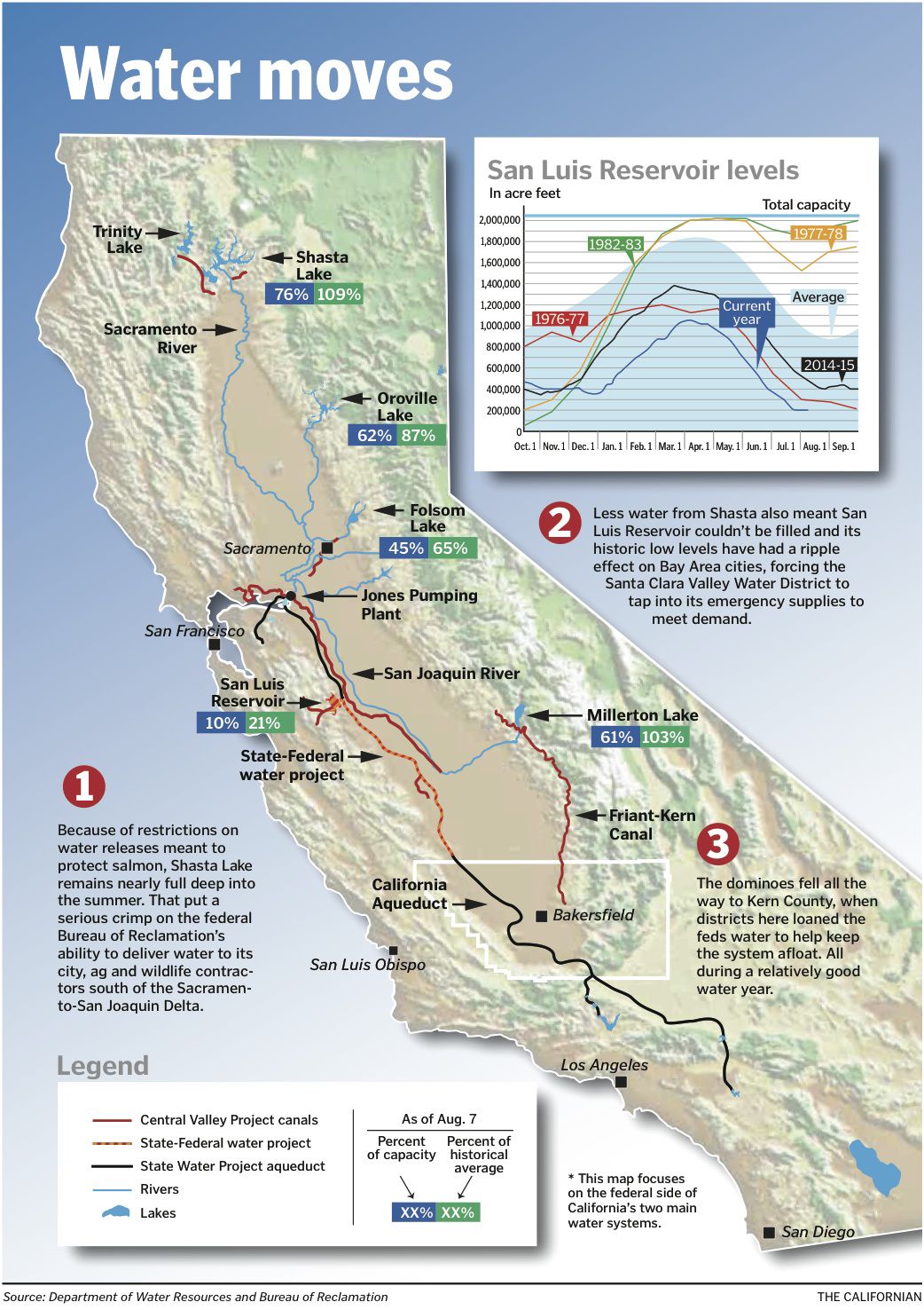
How water in Lake Shasta moves through the delta to San Luis Reservoir and on down to Kern users – or NOT, as happened in summer 2016.
Millions of Californians nearly had their water shut off late last month because the federal government ran out of water — sort of.
Yes, you read that right.
The federal Bureau of Reclamation ran out of water in the San Luis Reservoir and sent shutoff alerts (giving three days notice) to 26 districts it serves in the northern San Joaquin Valley and Bay Area.
One of those was the Santa Clara Valley Water District, which provides water to about two million customers including a few companies you may have heard of such as Apple and Hewlett Packard.
The shutoffs were narrowly avoided thanks, in part, to some quick water trades courtesy of the Kern County Water Agency and Arvin-Edison Water Storage District.
Still, San Luis Reservoir is at historic low levels. Dangerous lows, in fact.
And none of it should have happened at all, say water managers.
Because Lake Shasta is full to the brim.
Yes, you read that right, too.
The feds have heaps of water. Just not in the right place.
That, and other water maneuvers by the Bureau, have water managers up and down the state fuming that regulators’ overly strict operation of the federal Central Valley Project (CVP) has been so reckless it could cause problems years into the future.
HOW THE PLUMBING WORKS
To understand how this near-shutdown happened and why water managers are so worried for the future you have to understand the Central Valley Project (CVP).
Don’t be scared! We’ll take baby steps.
The CVP is the federal side of California’s two biggest water systems. The other is the State Water Project, which we will mostly ignore in this story.
To start, I want to make it clear this isn’t a “fish versus farms” rant. Though the Endangered Species Act is the underlying factor for how this all unfolded.
I’m just fascinated by how turning a valve — or not — 500 miles away can wreak havoc throughout the entire system.
So, here’s what happened.
PLAN, NO PLAN
After four years of unprecedented drought, we actually had a decent water year in 2015-2016 (in Northern California, anyway).
The two main reservoirs the CVP relies on, Shasta and Folsom, were full.
The Bureau of Reclamation was able to repay water it had borrowed the previous year and on April 1 told its contractors how much water it would be able to provide.
It promised 100 percent to all its contractors north of the Sacramento-San Joaquin Delta, 100 percent to so-called Exchange Contractors in the northern San Joaquin Valley and 100 percent to wildlife refuges south of the delta.
It also promised 55 percent of contracted allotments to its municipal users in the Bay Area and 5 percent to its west side agricultural contractors (Westlands Water District and a few other districts).
It made those promises based on approval of a so-called temperature plan for Shasta Lake by the National Marine Fisheries Services (NMFS).
Because Shasta is a linchpin in the survival of the endangered winter-run Chinook salmon, regulators have to make sure it has enough cold water to run down the Sacramento River at the end of October.
The temperature plan outlines how much water can be released from Shasta each month to preserve that needed chunk of cold water. Typically, downstream users can expect up to 13,000 cubic feet per second (CFS) a day in the river.
But salmon took a beating these last few drought years so the Bureau and NMFS created a more cautious plan with limits of 9,000 CFS in June, 10,500 CFS in July and 10,000 CFS in August.
With approval by all the regulating agencies, cities made their water supply plans, farmers planted their crops and wildlife refuges let out a sigh of relief after several dry years.
Happy days, right?
Not so fast.
DOWN TO A DRIBBLE
In early May, NMFS became concerned that initial lake temperature readings came in higher than predicted.
It scrapped the original plan and announced what many saw as a draconian reduction in Shasta releases, no more than 8,000 CFS all summer. In fact, June’s releases were cut back to 7,400 CFS at one point.
The announced reduction caused pandemonium among water contractors south of the delta and the Bureau set about re-negotiating the plan.
Compounding reduced supplies from Shasta was salt.
The delta was hit with a “king tide” starting in June that brought more salt from the San Francisco Bay than had been anticipated.
That required the Bureau, along with the state Department of Water Resources (DWR), to push more fresh water out through the delta to maintain water quality for municipal users.
That wasn’t as great a burden on DWR because it’s responsible to provide only 25 percent of that water and its main reservoir, Oroville, isn’t under the same winter-run salmon release restrictions.
Since the Bureau couldn’t increase its supply of fresh water out of Shasta because of NMFS, it had to move as much water out of Folsom as possible while keeping pumping out of its Jones Pumping Plant near Tracy to only a single pump.
The Bureau planned to move nearly 3,000 CFS daily through Jones and into the San Luis Reservoir. That was down to about 800 CFS this summer.
MAJOR WATER DEBT
The dribble coming out of Jones was quickly overmatched by demand, hence, the feds ran out of water in San Luis in about mid-June.
That’s when the borrowing frenzy started.
San Luis is a holding tank for water from both the feds and state.
They park water in San Luis and, from there, it goes to Bay Area cities, San Joaquin Valley farmers, wildlife refuges or all the way to Los Angeles through a variety of canals.
Contractors also store water in San Luis. Some is left over from previous years and some they purchase from third parties and pay a fee to store in San Luis.
That’s where the Bureau started.
In June and early July it took 270,000 acre feet that federal contractors had stored in San Luis, which caused severe howling and a lot of legal saber rattling from districts that had bought water at steep prices last year and paid to have it waiting for them in San Luis.
The Bureau is still working out how to answer those issues, I was told.
TOO LITTLE, TOO LATE
Finally, on June 28, NMFS approved a new plan for Shasta releases, which was basically the old plan.
But the increased releases for June were moot. June had passed.
The Bureau quickly burned through all its borrowed water and needed more.
It put out a call for help to all water contractors.
On July 15, Arvin-Edison, Kern County Water Agency and the state Department of Water Resources stepped up offering water through loans and exchanges.
The feds accepted but weren’t initially able to get the required permits to make the deals.
That’s why, on July 21, the Bureau sent three-day shutoff notices to all its contractors.
That includes the Santa Clara Valley Water District, which was already having to use its emergency water supplies out of Anderson Reservoir to blend with San Luis water because San Luis had dropped so low the water had become too fetid for Santa Clara to run directly through its treatment plants.
WHISTLING PAST THE GRAVEYARD
The Bureau finally got its permits and no one was shut off but it still only had a trickle coming from Shasta, the king tide to deal with and obligations to meet south of the delta.
It had to borrow even more water, all the way from Fresno and at least one Friant Division district.
As the calendar ticks toward mid-August, the Bureau is holding its breath.
That’s because salinity requirements will drop off mid-August, demand from north-of-delta users is expected to relax and NMFS actually agreed to keep Shasta releases at 10,500 CFS per day rather than throttle back to 10,000 CFS as outlined in the temperature plan.
Yes, water managers say, the crisis appears to be coming to a close.
REPAYING THE DEBT
But what about next year?
“The Bureau should be moving as much water south as they can right now (to repay the approximately 380,000 acre feet it owes),” said Ara Azhderian, water policy administrator for the San Luis & Delta-Mendota Water Authority. “But there doesn’t seem to be much opportunity for that this fall.”
Indeed, Ryan Wulff, branch chief for Delta Policy and Restoration with NMFS, reminded me these next few weeks are typically very hot so releases from Shasta will continue cautiously.
And even with this abundance, some say over abundance of caution (water managers tell me Shasta has 325,000 acre feet more cold water than the NMFS plan called for), Wullf predicted this fall’s salmon run will be paltry at best because of previous drought years.
And that, Azhderian said, is one of the most frustrating aspects of all of this.
“We need effective regulation so all these sacrifices actually result in something,” he said. “Part of the problem is we’re a victim of our own success.”
California’s water districts are so adept at moving, trading and exchanging water, the public never really knows how close we come to the cliff edge.
“People don’t have the foggiest idea of how it all works.”
TIMELINEMarch 31 — National Marine Fisheries Service (NMFS) approves the Bureau of Reclamation’s temperature plan for Shasta Lake. Enough cold water must be kept in the lake to release at the end of October for winter-run Chinook salmon. The plan would have allowed daily releases of 9,000 CFS in June, 10,500 CFS in July and 10,000 CFS in August.
April 1 — Based on NMFS’ approval of the Bureau’s temp plan, the Bureau announces water allocations of 5 percent of contracted amounts for west side ag districts, 55 percent for municipal clients and 100 percent each for wildlife refuges, below delta exchange contractors, above delta Sacramento Valley diverters and Sacramento Valley Settlement Contractors.
Mid-April — Shasta fills to near capacity of 4.3 MAF, Folsom fills 850,000 AF.
April through May — Bureau only runs one pump out of six available in its Jones Pumping Plant near Tracy. One pump moves 800-1,000 CFS of water per day.
May 2 — NMFS rejects the original temp plan as early lake temperatures come in warmer than predicted. NMFS states it will reduce Shasta releases to 8,000 CFS all summer. The Bureau and NMFS enter negotiations for a new plan.
Month of June — Because there is no temp plan in place, NMFS keeps Shasta releases to 7,400 CFS. Bureau quickly begins falling behind in filling San Luis Reservoir, which is used to meet its south-of-delta obligations.
June through July — A “king tide” creates salinity issues in the delta, forcing the Bureau and state Department of Water Resources (DWR) to push 8,000 to 12,000 CFS per day to the ocean through releases from Folsom and Oroville. Typically, the agencies would have to move 7,500 CFS through the delta for salinity.
Mid-June — Bureau has no water in San Luis Reservoir and is forced to borrow 270,000 AF from federal contractors who had stored water there from previous years or who had purchased water from third parties and stored it in San Luis. That water is used to meet the Bureau’s April allocations but only lasts until mid July.
June 28 — NMFS agrees to a second temp plan that allows for releases of 9,000 CFS in June (but June has passed), 10,500 CFS in July and 10,000 CFS in August.
July 6 — Santa Clara Valley Water District is forced to tap its emergency supplies at Anderson Reservoir to blend with water out of San Luis because the San Luis water had become fetid as lake levels dropped dramatically. Santa Clara has used 12,000 AF of its emergency supplies.
July 15 — The Bureau is again out of water in San Luis. It asks for help from all contractors including those on the State Water Project. It inks a deal to borrow 12,000 AF from Arvin-Edison Water Storage District, a Friant contractor,* and exchanges 45,000 AF of federal water from Millerton with the Kern County Water Agency, a state contractor. The Bureau also borrows 38,000 from DWR. But it needs approval from the State Water Resources Control Board to make those trades.
July 21 — The Bureau doesn’t get approval and sends shutoff notices to 26 water districts alerting them pumping would cease in three days.
July 22 — Shutoff is narrowly avoided after an all-night session between Bureau and Water Board employees results in the needed approvals.
July 22 — The Bureau approves an increase in allocations to contractors on the Friant side of the CVP, which takes water from Millerton, igniting a firestorm of criticism from other federal contractors who were still in danger of being shut off.
July 22 — Westland’s Water District agrees to take 40,000 AF of water it had purchased and stored in San Luis as an emergency stash, rather than what was promised by the Bureau in April. It also gives 5,000 AF from that emergency stash to San Luis Water District.
July 25 — Bureau borrows another 10,000 AF from Fresno Irrigation District and the City of Fresno and sends it down the San Joaquin River from Millerton for west side ag contractors.
Aug 1 — Bureau borrows another 5,000 AF from a Friant district to send down the San Joaquin from Millerton for west side contractors. Total borrowed, not including Westlands water, is 380,000 AF.
Aug. 1 — At 205,000 AF, San Luis Reservoir is lower even than it was in 1976-77, one of the driest years on record.
Aug. 10 — NMFS agrees to keep Shasta releases 10,500 CFS daily through August rather than dropping down to 10,000 CFS as planned.
Future — There are no certain plans for how the Bureau will repay the 380,000 AF it borrowed.
West side federal contractors believe the debt should be paid out of Millerton.
Friant division contractors (which include several districts in Kern County) believe the water should be repaid through increased pumping out of the Jones facility this fall.
Either way, all sides are hoping this debt doesn’t reach into the 2017 water year.
*The CVP south of the delta is split into two halves. One serves districts in the Bay Area and along the west side of the valley, the other serves districts in the Friant Division, which includes Arvin-Edison, Shafter-Wasco Irrigation District and Kern Tulare Water District in Kern County.
This is an oldie, but a goodie about how water is “moved” around to make deals…
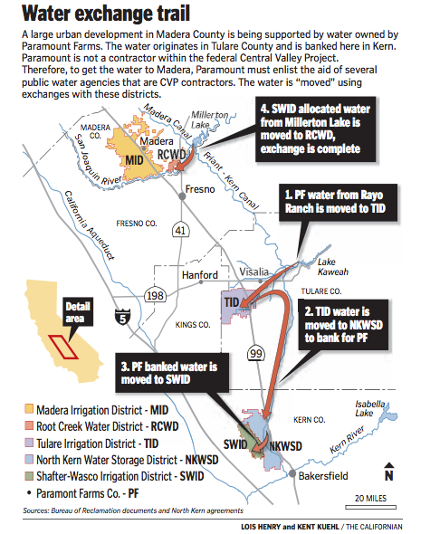
Water banked in Kern County is used to develop houses in Madera, three counties to the north, through a series of paper water transfers.
LINK to original article:
http://www.bakersfield.com/news/lois-henry-how-water-from-kern-grows-sprawl-in-madera/article_2c11936a-4542-56f2-b81b-d0f32e3e1c5c.html
By LOIS HENRY, Californian columnist lhenry@bakersfield.com
So, a pile of water banked in Kern County is being used to support a massive urban development in Madera County.
Before you try and wrap your head around how that’s geographically possible, there’s the whole question of whether the banked water (and other water slated for the project) even can be used for that purpose.
Then let’s tack on whether it’s cool that public resources are being used throughout this deal to basically benefit private businesses.
I swear when I started this I just wondered how the water would “move” up to Madera.
Why can’t anything ever be simple?
Let’s start in Madera County.
A 2,000-acre development called Gateway Village was proposed way back in the 1990s by Castle & Cooke as a “master planned” community of more than 6,500 homes with parks, commercial space, etc., in the southeast corner of the county just north of Children’s Hospital Central California along Highway 41.
The taps and toilets for all that urbanization will require more than 6,300 acre-feet of water a year, according to Gateway’s environmental documents. (Imagine 6,300 football fields each covered with a foot of water — it’s a lot).
Of course, the question is where will that water come from?
The development is in the Root Creek Water District, formed a little before Gateway Village was first proposed. It covers about 9,200 acres and is home to citrus and grape farming.
Root Creek’s groundwater is severely overdrafted and the district has no other surface supplies.
The district is not a contractor within the federal Central Valley Project (CVP), which moves water through the Friant-Kern Canal from Millerton Lake north of Fresno to the Arvin-Edison Water District in Kern County.
Gateway developers came up with a plan under which Root Creek would buy “excess” water from the neighboring Madera Irrigation District, which is a CVP contractor, and from the Bureau of Reclamation, which runs the CVP.
Both of those supplies are described as “when available” in Gateway’s documents.
Considering the vagaries of Mother Nature, the Madera County Board of Supervisors wasn’t comfortable with that and sent Root Creek/Gateway out to look for a backup supply of water.
They found it in Kern County.
First, a quick stop in Tulare County.
That’s where the Root Creek “backup” water originates.
It’s owned by Paramount Citrus Association, one of the many companies owned by billionaires Lynda and Stewart Resnick.
Paramount owns Rayo Ranch in Tulare County, which has rights to 9,000 acre-feet a year of Kaweah River water.
Paramount doesn’t use all its Rayo water, so, for years, has moved some of it through the CVP system to other Paramount lands.
Like Root Creek, Paramount is not a CVP contractor. It has to partner with Tulare Irrigation District, which is a CVP contractor, to move that Rayo water.
Paramount releases its Rayo water to Tulare Irrigation, which, in turn, sends a like amount of water down the Friant-Kern Canal to the North Kern Water Storage District here in Kern County. North Kern isn’t a CVP contractor but has access to the Friant-Kern Canal.
In order to use the CVP system, Paramount had to have an “environmental assessment” (EA) approved by the Bureau of Reclamation.
In that EA, it very clearly states that the Rayo water is only to be used for farming and groundwater recharge.
It also states the water cannot be used in such a way that would trigger any land use changes, such as from ag to urban.
OK, so now, much of that Rayo water is banked in North Kern, where Paramount is a huge landowner. Paramount also bought some water from the Nickel family and has it banked in North Kern.
Here’s where Root Creek comes in.
In 2009, another Resnick company, the Westside Mutual Water Company, made a deal with North Kern to pull some of that banked Paramount water out and give it to neighboring Shafter-Wasco Irrigation District for ultimate delivery to Root Creek in Madera.
The deal is phased, starting at 3,500 acre-feet of water per year up to a maximum of 7,000 acre-feet, if needed.
Shafter-Wasco is a CVP contractor so it can take that Paramount water and have the Bureau of Reclamation release a like amount of water from Millerton Lake to the Madera Irrigation District.
Madera Irrigation would then deliver it to Root Creek through two turns-outs soon to be constructed on the federally owned Madera Canal.
Again, all those swaps, including constructing the turnouts, had to pass muster with the Bureau of Reclamation in an EA.
And, again, the Bureau EA clearly states that the Paramount (Westside Mutual) water and any water Root Creek buys directly from Madera Irrigation or the Bureau is to be used only for ag or groundwater recharge.
It can’t be used in a manner that results in land use changes — ag to urban.
But that’s exactly what this water will do. That’s what it’s intended to do. That was the whole point of this long, elaborate deal.
I asked the Bureau about that.
First, I confirmed that, yes, the Bureau did put those ag-only limitations on all the water movements involved in this deal and that the water cannot be used for “M and I” (municipal and industrial).
The Bureau does follow up on these deals annually but mostly to make sure the right amount of water is being moved to the correct recipients.
It’s up to Root Creek to tell the Bureau how it used the water.
Um.
My guess, backed up by what Root Creek’s attorney told me, is Root Creek will simply say the water was used for groundwater recharge per the Bureau’s limitations.
End of story.
Of course that’s not the end of the story because the water will have been pumped right back out and put into the taps and toilets of Gateway Village, as was the intent all along.
I’m not arguing against Gateway Village. It may be the greatest piece of leap frog development ever to grace the fertile fields of Madera County.
That’s not the point.
The point is that taxpayers, who built and own the CVP system, seem to be giving quite an assist to the bottom lines of two private enterprises.
Oh, and Root Creek was also awarded a $4 million grant from the State Department of Water Resources to help pay for those turnouts on the Madera Canal in order to curb the district’s severe groundwater overdraft.
All of which makes me wonder, what’s in it for us?
The owners of Gateway Village (Castle & Cooke sold it in 2010 to unnamed investors) aren’t going to give the Bureau a cut of every lot they sell.
And Paramount/Westside Mutual certainly isn’t going to share any of the loot it makes off selling water to Root Creek.
The loot, by the way, could be pretty substantial.
Paramount/Westside Mutual has spent at least $2.6 million up front to sink four wells and build pipelines between North Kern and Shafter-Wasco and pay both districts “stand by” fees for the water.
But companies appear to have made about $3.5 million back from Root Creek, which has been paying $180 per acre-foot a year for the last five years for Paramount/Westside Mutual to hold its water in reserve.
If Root Creek ever needs the water, the price will go up by $420 per acre-foot for a total of $600 per acre-foot.
I gleaned most of those figures by scouring through agreements with the ag districts and talking to district managers and the attorney for Root Creek.
I would have liked to get a more accurate picture of the finances involved but Paramount/Westside Mutual wasn’t talking.
“We’re a private company,” I was told by Westside Mutual President Bill Phillimore. “I don’t think there’s any advantage to us participating in this story.”
Yeah, and that’s what concerns me.
Opinions expressed in this column are those of Lois Henry, not The Bakersfield Californian. Her column appears Wednesdays and Sundays. Comment at http://www.bakersfield.com, call her at 395-7373 or e-mail lhenry@bakersfield.com
LINK to original article: http://www.bakersfield.com/columnists/lois-henry-water-water-everywhere-but-can-we-keep-it/article_d1cd4c96-6115-582c-9707-11e07a06ae46.html
By LOIS HENRY lhenry@bakersfield.com
Will we get the water?
That’s the question everyone’s been asking. (And by everyone, I mean the other five or six people I know who are as weirdly interested in water as I am.)
Storms are dumping, rivers are rising and lakes are filling — finally.
Will we be able to squirrel that water away for the next dry spell?
Or will California flush it out to sea?
Yes and yes.
The state Department of Water Resources (DWR) and federal Bureau of Reclamation are planning to move as much water as possible into storage, said Kern County Water Agency General Manager Curtis Creel.
There are concerns about the endangered delta smelt fish that must also be addressed, so DWR and the Bureau are coordinating with their counterparts in the U.S. and state departments of Fish and Wildlife.
But there’s so much water pouring into the state right now, with more coming, that Creel wasn’t too worried about the smelt’s share.
“At some point, even with the ESA (Endangered Species Act) in place, there will be more water in the system than we can physically take,” he said.
Locally, water folks are already sucking up as much as they can.
Some of that is “extra” water from this season’s storms, some of it isn’t.
For instance, local water agencies are getting a big slug of water out of Millerton Lake east of Fresno, which has been dumping water for the past week and a half for flood control.
That water comes down the Friant-Kern Canal (that’s the one behind Lowe’s on Rosedale Highway) and goes to Central Valley Project (CVP) contractors in Kern.
When the CVP (which is federal) is in flood control mode, that means contractors take as much water as they can.
Which is exactly what they’re doing through a network of banking and recharge agreements with other entities.
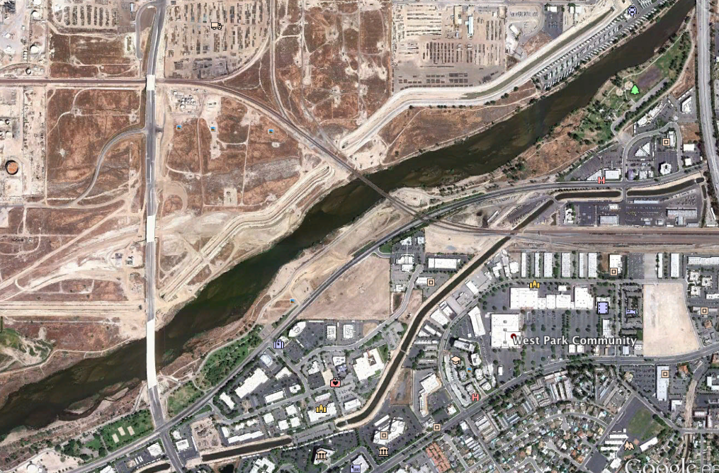
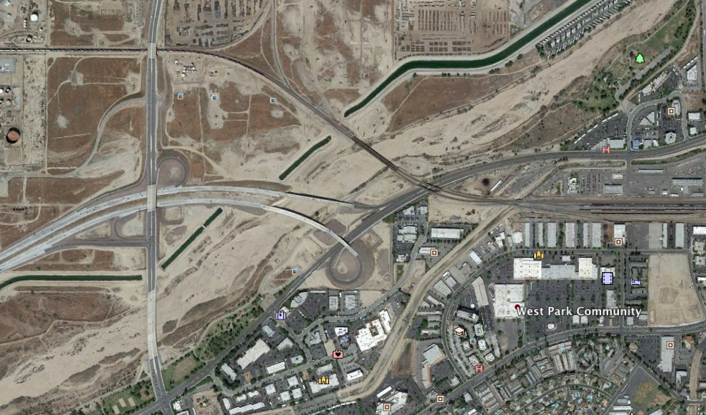
Which is why you now see a “river” in the Kern River bed from Coffee Road to a bit west of the Stockdale Highway bridge.
That’s not Kern River water.
It’s actually San Joaquin River water coming out of Millerton headed to groundwater recharge ponds on behalf of a number of local water agencies.
Meanwhile, the California Aqueduct on the west side of the valley (part of the State Water Project) is bringing what’s known as “carryover” water out of San Luis Reservoir that local districts are socking away in the Kern Water Bank and Semitropic Water Storage District water bank.
Carryover water is water that districts bought the previous year and are allowed to store in San Luis until needed the next year.
With water being pumped out of the Sacramento-San Joaquin Delta fast and furious, no local agencies want to lose their carryover water if San Luis gets too full.
“We are scrambling to recharge all the water we can,” said Jonathan Parker, general manager of the Kern Water Bank Authority.
Generally speaking, the Kern Water Bank can recharge up to 60,000 acre feet a month. That pace slows as the bank fills.
Which is why water folks are watching weather conditions closely, ready to throttle back if needed.
Because everyone also has eyes on the Kern River and Isabella Lake.
“If the Kern has mandatory releases, I would expect all our (groundwater banking) participants would take any of that water offered,” Parker said.
Under a mandatory release situation, when the Army Corps of Engineers dumps water out of Isabella for flood control and dam safety, it becomes a kind of free-for-all.
There’s no cost for the water or moving it, since it’s all gravity-fed.
That’s like manna water — everybody wants some.
So, you don’t want to fill up on delta water if Kern River water is in play.
But that’s tricky to predict.
Right now, Isabella is at 170,000 acre feet, according to Kern River Watermaster Dana Munn.
Starting Feb.1, the Corps could let the level rise to 245,000 acre feet.
But it depends on how big the snowpack is and is expected to get.
A recent model shows the snowpack at 120 percent of normal, which would allow river interests (several ag water districts and the City of Bakersfield) to store up to 245,000 acre feet.
With more storms on the horizon, though, the Corps could get antsy about holding on to that water.
Or, as Munn noted, it could be like 1997.
Back then, we had a huge December and January, then it all came to a screeching halt.
You may have heard that a landmark California water bill was passed in late 2016.
OK, maybe you hadn’t heard.
But you’re gonna now.
There are a lot of moving parts to the legislation, which was pushed by an odd alliance of U.S. Sen. Dianne Feinstein, D-Calif., and faithful GOP Rep. Kevin McCarthy of Bakersfield (dissect the politics on your own time).
Anyhow, right now a couple of pieces of that bill are kicking in and water managers expect they will result in greater flexibility, meaning more water and, most importantly, greater certainty to water users.
It’s all about flow.
In average years, there usually isn’t enough water coming into the Sacramento-San Joaquin Delta from the San Joaquin River to push water north through the delta as the massive pumps that feed both the state and federal water projects pull water south near the town of Tracy.
That creates a “reverse flow” in what’s known as the Old and Middle River channels and is considered bad for endangered fish species.
So fishery agencies, including the California Department of Fish and Wildlife and National Oceanic Atmospheric Administration, set a standard reverse flow amount they felt the fish could tolerate.
No more than 5,000 cubic feet per second (CFS) can flow toward the pumps in the Old and Middle River channels.
The fishery agencies could be more restrictive than 5,000 CFS, but rarely allowed any greater flow unless storms fattened the San Joaquin River to the point that it pushed water north harder than the pumps could suck it south.
You may think this is all esoteric but it has a real, direct local impact.
When flows were ratcheted down it meant pumping had to slow or even stop, which has meant a lot less water for farms and cities in our neck of the woods.
And it was all based on fishery agencies’ concerns, not data.
The McCarthy-Feinstein legislation changed that.
Now, if agencies want to curtail flows toward the pumps below 5,000 CFS, they must provide scientific evidence that doing so is needed to protect the fish.
The legislation also allows the Department of Water Resources and Bureau of Reclamation to seek higher flows as long as they, likewise, provide evidence that increased flows won’t harm the fish.
What that’s meant this year is that flows toward the pumps haven’t been cut below 5,000 CFS, allowing a lot more water to move south.
The other part of the legislation that will kick in this year involves stormwater payback.
Remember, in heavy water years like this one, fishery agencies could allow flows toward the pumps to increase.
But previously, those agencies would then require the water be paid back, explained Kern County Water Agency General Manager Curtis Creel.
How the agencies got the water back was somewhat arbitrary.
“At some point in the future, let’s say three months after the storm event, the fisheries might say it would be OK to stay at 5,000 CFS but we’re going to drop you down to 4,000,” in order to repay the “extra” water that was captured earlier, Creel said. “They would artificially limit you because there might be some benefit to the smelt.”
That kind of management created a lot of uncertainty for water managers south of the delta.
The McCarthy-Feinstein legislation did away with the payback requirement.
“It’s real change and it’s very positive,” Creel said of the legislation. “It did not change the Endangered Species Act in any way.”
It simply puts both fishery and water agencies on notice that the congressional preference is for delta operations to lean toward the upper allowable limits unless there is evidence that justifies either cutting back or going above.
By LOIS HENRY
Californian columnist
July 30, 2016
http://www.bakersfield.com/news/lois-henry-taxpayer-funded-water-deal-that-makes-me-go/article_79f6c1b9-92ed-5b4b-99f6-e2881c1ad25d.html
The Nickel water came to my attention again recently.
Tejon Ranchcorp released its draft environmental impact report for its proposed Grapevine community of 12,000 new houses at the base of the Grapevine.
If the development is approved, it will be Nickel water flowing through the taps and toilets of all those homes.
I like following the Nickel water partly because it’s fascinating to see how many development dreams it continues to fuel.
And also because the Nickel water was part of a deal that cost taxpayers $10 million back in 2000 and I like to see how that investment is working out for us.
First, the background.
The Nickel family owned land up in Kings County that actually got a slug of Kern River water every so often when the river ran high.
After the Isabella Dam was built, George Nickel made a claim that storing water in Isabella Lake would deprive him of that high flow water.
The issue was settled with the other river interests agreeing that Nickel had rights to high flow water — now known as the Lower River right — and he was allowed to rent storage in Isabella.
Fast forward to 2000.
The late Tom Clark, who used to work for Nickel, was general manager of the Kern County Water Agency.
The agency made a deal to buy Nickel’s Lower River right and storage in Isabella for $10 million plus the agency agreed to give Nickel 10,000 acre feet of water every year in perpetuity.
That $10 million was public bond money, by the way.
It was part of Proposition 13 passed in 2000 to support safe drinking water, water quality and water reliability.
The agency’s deal definitely created reliability for the Nickel family, which now has 10,000 acre feet a year, rain or shine, to sell up and down the state. And, boy has it (see sidebar).
As for taxpayers who funded the deal, I’m not so sure how we made out.
The Lower River right has only materialized three times in the last 16 years, yielding about 300,000 acre feet to the agency.
Now that is a load of water. But where’s it all gone?
The agency sold a big chunk, 118,666 acre feet, mostly to its member units, local agricultural water districts.
A little more than 90,000 acre feet have been put into the agency’s Pioneer groundwater bank.
And more than 58,000 acre feet have been used to made good on the agency’s 10,000-acre-foot-a-year obligation to the Nickel Family LLC.
Oh, and a little more than 12,300 acre feet have been sold to the Western Hills Water District to support a swanky golf resort/housing development in the bone dry foothills west of Interstate 5 up near Modesto. (Who on earth thought that was a good use of Kern River water? Sheesh!)
Excluding the water sent to the Nickels and Western Hills, about 230,000 acre feet stayed put and was used here in Kern County, which was Clark’s argument for the deal back in 2000.
If the agency hadn’t bought the Lower River right, Clark told me several times, that water would have barreled down the river channel, gone into the intertie and on to the California Aqueduct where downstream users could lay claim to it. (Yes, but no one ever got extra water. It would just mean less pumping from the Sacramento-San Joaquin delta.)
That’s because the Nickels only had so much storage in Isabella. Once that was full and assuming the family had nowhere else to park it, that water was on the loose.
Okaaaay.
Except, I would argue back with Clark, that meant anyone — including the agency, the Kern Water Bank, Rosedale Rio Bravo Water Storage District, or anyone else with recharge facilities and the ability to divert water off the river — could capture it and use it for free.
I didn’t see the wisdom in the deal but Clark never stopped trying to convince me. I do miss that guy.
Anyhow, remember that the Lower River right was paid for by all Californians via a bond. But it was used mainly by large farming interests, which have made large profits from that water.
And, I would point out, our aquifer didn’t benefit. We are critically overdrafted — meaning more water is being pumped out than put back in.
So, that $10 million Lower River water hasn’t increased the “reliability” of the aquifer, which affects all of us.
Besides all that, the environmental documents the agency used to approve the Lower River deal were based on the premise that some additional bond money obtained by the agency would be used to build wells that would restore the river through Bakersfield at least part-time.
That never happened.
In fact, for the past few years, the agency has pumped the heck out of those wells to meet drinking water demand, which makes zero sense to me if the agency truly is flush with Lower River water stored in its Pioneer groundwater bank.
Some people got rich off this deal, some people got water and some got both.
But I still don’t see what taxpayers got out of it.
Opinions expressed in this column are those of Lois Henry. Her column runs Wednesdays and Sundays. Comment at http://www.bakersfield.com, call her at 395-7373 or email lhenry@bakersfield.com.
LOIS HENRY ONLINE
Read archived columns by Lois Henry at Bakersfield.com/henry.
Related Info
Watering suburbia
The 10,000 acre feet of water provided to the Nickel Family LLC by the Kern County Water Agency has been sold in long-term contracts to various entities intent on using it for development.
Most of these developments haven’t broken ground or been fully built yet so much of this water has been stored in groundwater banks or sold on a one-time basis to farming operations.
Here’s who currently owns the Nickel water:
• 2005, Newhall Land and Farming Co. signed a long-term contract to buy 1,607 acre feet. It plans to use that water to help supply 22,000 homes in the Santa Clarita area.
• 2007, DMB Communities II Inc. signed a long-term contract to buy 8,393 acre feet. DMB had tried to use the water for a controversial development in the northern California community of Redwood. But that met with severe opposition.
• 2013, DMB assigned 1,700 acre feet of its Nickel water to CV Communities and 6,693 acre feet to Tejon Ranchcorp. Tejon plans to use 6,278 acre feet of that water for the proposed 12,000-home Grapevine development. No word on what it plans to do with the remaining 415 acre feet.
• 2016, CV Communities assigned its 1,700 acre feet to Antelope Valley‐East Kern Water Agency. CV Communities plans to use that water for a proposed 758-home development called Avanti North near Lancaster.
Cash cow
The Kern County Water Agency gets 10 percent of what the Nickel Family LLC earns off its water sales.
Here’s how much the agency has made over the years:
LOIS HENRY
Californian columnist
Feb. 26, 2013
http://www.bakersfield.com/columnists/lois_henry/lois-henry-there-goes-more-kern-river-water-over-the/article_4614262e-859f-5d4a-918b-e8d706710f77.html
Keeping track of Kern River water leads to all kinds of interesting little snarls.
For example, our river water has created what could become a major dustup for the Castaic Lake Water Agency.
The agency, just to Kern’s south, is the state water contractor that supplies the Santa Clarita area. That includes Valencia and the controversial 21,000-home Newhall Ranch development.
The dust up involves whether the Castaic agency should have obtained permission from the California Public Utilities Commission before buying Valencia Water Co. for $73 million last December.
This is all in Los Angeles County so you may not think you care, but believe me, you should.
That’s because the Castaic agency bought Valencia Water Co. in order to make sure Newhall Ranch taps and toilets get water — Kern River water.
How’d that happen? Glad you asked.
The water was owned by the Nickel family here in Kern County. It was flood water on the lower river (also known as the Hacienda right) that only materializes in very high water years. The average is figured at 50,000 acre feet a year.
In reality, the Nickels had way too much water some years and didn’t get a drop others.
In 2000, the Kern County Water Agency — using public bond money that the agency had pledged to use for Kern River restoration — paid the Nickel family $10 million for the Hacienda right.
As part of the deal, the Kern agency also promised to give the Nickels 10,000 acre feet of water every year. Hard and fast, drought or no drought, the Nickels get that water.
That gave the Nickel family a huge asset that could be divvied up and sold.
And they sell it they have, about 1,600 acre feet a year to Newhall Ranch and 8,400 acre feet a year to Development company DMB Associates.
DMB had grand plans to use the water, through a series of swaps, for a very controversial development in Redwood City, but those plans appear to be on hold.
Not so with the Newhall Ranch development down south.
Things had been moving along until the Castaic agency bought the Valencia Water Co. (owned by Newhall) in December and got smacked with a legal action by opponents of Newhall Ranch.
Valencia Water Co., is a water retailer governed by the PUC. Hence, the PUC needed to bless the union before the honeymoon. But someone forgot to make that call.
When I first started asking about the legal action against the purchase, Castaic agency General Manager Dan Masnada chalked it up to a paperwork issue that his agency would clear away momentarily.
Not quite.
A PUC administrative law judge ordered Castaic to go through the application process, then denied Castaic’s plea to reconsider that order and most recently denied Castaic’s motion to dismiss the action entirely. (Incidentally, Castaic filed its dismissal motion on Friday and the judge zapped back his denial on Saturday. Yowser.)
There are a ton more details that raise questions about the Castaic/Valencia Water Co. purchase deal — including a proposed 15 percent rate hike, after Valencia ratepayers just had their bills increased by 3 percent last November.
But I was most interested in the Nickel water.
Masnada said Castaic’s acquisition of Valencia Water Co. wouldn’t affect the Nickel water one way or another. Newhall Ranch owns that water (under a 30-plus-year contract) and it will ultimately be used for that development, he said.
Castaic’s role in all this is simply to facilitate movement of the water, via the California aqueduct, Masnada said. Oh, and as part of its purchase deal with Valencia Water Co., Castaic will get whatever Nickel water is deemed surplus after Newhall Ranch is fully built out and all its needs are met.
“We’re hoping to get the District Attorney or Attorney General to look into this,” said Lynne Plambeck, president of Santa Clarita Organization for Planning and the Environment.
Her contention is Newhall Ranch would never have been able to get the Nickel water without the help of Castaic and so they made a deal with Castaic that uses public facilities and public funds for one company’s private gain.
I don’t know about all that, but I have to wonder if our Kern River water had stayed where it belonged, if all this strife might be avoided.
Opinions expressed in this column are those of Lois Henry, not The Bakersfield Californian. Her column appears Wednesdays and Sundays. Comment at http://www.bakersfield.com, call her at 395-7373 or e-mail lhenry@bakersfield.com
VIDEO
http://www.bakersfield.com/columnists/water-shortage-in-california-how-far-will-it-let-us/youtube_d6e5e128-afbd-5251-a205-0620f8778110.html
LOIS HENRY
THE BAKERSFIELD CALIFORNIAN, first ran Feb. 13, 2016
Perhaps it seems crazy that Bakersfield has actually ramped up home construction during one of the worst droughts in California history.
Especially crazy since the city’s river rights dried up last summer, bringing 20,000 residents harrowingly close to running out of water.
Add to that the fact that we have a boatload of development left over from the pre-recession days already approved.
Oh, and we sit atop one of the most over-pumped aquifers in the state, something new law aims to change.
Yet from 2012 through 2015, the drought years, Bakersfield issued a combined 5,139 building permits for new single-family homes.
All of which got me wondering how much more development Bakersfield’s water supplies can sustain.
So I asked around.
I kind of figured there’d be a number. Or a guesstimate. Or someone besides me mulling over the issue considering we actually hit the bottom of the barrel last summer.
Mostly what I heard back was “That’s a really good question.”
Hmph.
To be fair, water and planning agencies do track development and water supplies. To the drop.
But that’s just it. Each entity tracks its own supplies, its own use and its own development plans.
Since all those straws are poked into the same milkshake (nod to “There Will Be Blood”), I thought there must be some way to figure out the cumulative demand versus total supply.
Simple, yes? No.
RABBIT HOLE
No one agency keeps an overall running tally of our water supplies and the impact each new development will have on that supply.
If a development includes more than 500 homes, a full-blown environmental review, including cumulative water impacts, is required. But I noticed a lot of large developments appeared to be done piecemeal, staying under that 500-home trigger.
And urban water reports (required by the state every five years), which are typically used to give developments the OK, contain vague averages in terms of water supplies and the reports aren’t uniform from one purveyor to the next, making it difficult to find definitive numbers for how many more houses our water can support.
New groundwater legislation passed last year by the state will force a much more strict accounting, but not for several years.
Meanwhile, we have about 58,000 housing units either approved or in some stage of construction in and around Bakersfield.
Of those, I counted about 12,500 lots in developments in the city that are in some phase of construction, leaving about 37,500 lots in the approved but holding stage, which could mean they are months, years or forever from being built. About 8,000 lots are in county areas around metro Bakersfield but the county didn’t track which are under construction or in the holding stage.
(By the way, that 58,000 doesn’t include the 12,000 homes proposed by Tejon Ranch at the base of the Grapevine, nor the already approved 3,000 homes in Shafter just over the city line at 7th Standard Road.)
So, if you figure each of those 58,000 homes will hold about three people, that means an increase in population of 174,000 people, assuming it all gets built, of course.
Each of those folks will use, say, 250 (a number that will go down if conservation measures are kept in place) gallons of water per day, which works out to about 16 billion gallons a year, or 52,000 acre-feet.
That would be on top of the 120,000 acre-feet a year that existing residents, businesses, parks and lakes require.
Arguably, that wouldn’t be a huge amount of “new” demand assuming most of that development occurs on existing farmland and ag to urban is considered a wash in terms of water use. A lot of those new homes, though, are slated for the unfarmed northeast.
Either way, such expansion would be more “hard” demand on what has already been deemed a critically overdrafted aquifer.
When I say overdrafted, I mean we pump about 300,000 and 400,000 acre-feet a year more than goes back in. (During the drought, it’s been a million acre-feet). That’s, of course, including the draw from Kern’s 800-pound economic gorilla — agriculture.
When water is short, almond trees can be pulled up and cotton plowed under. Houses can’t go dry.
KERN RIVER, DEVELOPMENT LIFELINE
The City of Bakersfield has always boasted a healthy water supply thanks to its ownership of a large chunk of the Kern River.
That didn’t stop a near catastrophe last summer when the river all but dried up and Cal Water had to do some fast dealmaking to get water to its northeast and northwest treatment plants. (See side box.)
Aside from the river, Bakersfield and Cal Water (the main water purveyors in the city) buy some water from the state through what’s known as Improvement District 4 (ID4).
But, by and large, the main source is groundwater.
The city has long maintained that because of recharge from the Kern River, it has a solid groundwater base.
That’s probably true.
Unless you’re in a severe, sustained drought, as we’ve been.
Even without drought, the days of assuming that groundwater is an unending supply are over.
PLANNING KNOCKED FOR A LOOP
“The whole world’s turned upside down and I honestly don’t know how it will all sort out,” said Kern County Planning Director Lorelei Oviatt.
Land-use planning has become an evolving issue under the state’s new Sustainable Groundwater Management Act (SGMA).
“Because now we have a new regulation over the groundwater that we didn’t have before,” she said. “What if it turns out that things in the General Plan that we said we were going to build, we don’t have the water for? How’s that going to turn out? I don’t know the answer to that.
“Right now, the (ag) water districts are all worried about the new law, but planning seems like an afterthought.”
Under the new state law, everyone with a stake in the aquifer (pretty much everyone) has to agree on how much each entity can pump without creating an overdraft.
We’re a long way from a number, but what if it were only a half acre-foot per acre of land? What would that do to planning? To property rights? Who gets priority for that water?
These are questions the county has been wrestling with in different forms for a number of years in other parts of Kern.
For instance, some developments in outlying areas have been required to provide proof of two water sources, homes have been assigned individual water budgets and anyone seeking a General Plan amendment first has to show the county its water source, Oviatt said.
“Those are some of the ideas we’re going to discuss when we start our General Plan update in a couple of months,” she said. “But for some county areas in the metro Bakersfield area, like western Rosedale, I don’t have any solutions yet.”
For her part, Bakersfield’s chief planner, Jacqui Kitchen, agreed that local land use and water agencies must be on the same page going forward.
Though the planning future is murky for both, Oviatt acknowledged the city is in a better position by virtue of its river ownership.
“It may go down some years, but they still have it.”
Or do they?
WATER ACCOUNTING 101
Even the city’s river rights are getting a critical eye as the deadline for a groundwater plan under SGMA approaches.
What if recharge from Kern River water run down the river channel couldn’t be claimed by any particular entity? What if, once it seeped into the aquifer, it was considered “native water”? How would that affect the city’s water assumptions and its planning?
“In adjudicated basins, native river water is claimed by the entire basin,” said Eric Averett, general manager of the Rosedale-Rio Bravo Water Storage District and director of the Kern Groundwater Authority, which is working to create a Groundwater Sustainability Agency per SGMA rules.
An adjudicated basin means water supplies have been sorted out by a court rather than through mutual agreement. If such adjudications have any kind of precedent, that could change how Kern River recharge is accounted for, according to Averett.
No. No. No. And heck no, was the essence of the response I got from Bakersfield’s water resources manager, Art Chianello. (He’s too nice a guy to say “hell no.”)
There’s nothing “native” about the Kern River. It’s divvied up, spoken for, stored and carefully controlled as to when it comes down the river channel.
“It’s not willy-nilly stream water,” he said. “It has someone’s name on it.”
He noted that ID4 claims losses (recharge, seepage, all the same thing) incurred when it moves water through the unlined portion of the Cross Valley Canal.
The city’s claims on river recharge are no different.
OK, but I recall that the city was extremely watchful when ID4 pumped a load of water from wells near the Cross Valley Canal in 2014 and 2015, saying it hadn’t specifically banked water to those wells.
“Shell game” was a phrase I heard from a number of city officials concerned about that pumping.
Funny, that’s the exact same term I heard in reference to how the city accounts for water as well.
“I think it’s an open question,” Averett said of Kern River water. He said that except under certain very limited circumstances that Rosedale-Rio Bravo can’t run its water down the river channel and call it “banked.”
“Rosedale wouldn’t get credit for that water,” he said. “This is just one of the difficult questions we’re working with in groundwater of who counts what, how’s it counted and who gets credit.”
A longtime water observer told me he could see Averett’s point but predicted if anyone tried to make a serious claim for the city’s (or any Kern River rights holders’) recharged river water, that would provoke a fight with all the river interests.
LIVING IN OUR WATER MEANS
All of which gets me no closer to an answer to my initial question, how much development can our water sustain?
I posed the question to City Councilman and City Water Board Chairman Harold Hanson, whose ward covers the rapidly expanding southwest area of town, and Kern County Supervisor Mike Maggard, whose district encompasses the growing northeast.
Both men agreed it’s a serious question. But neither had an answer.
“In Bakersfield, kind of fortunately and unfortunately, water hasn’t been a real issue up until the last few years so people haven’t really thought about it,” Hanson said. “I think there will come a time when we’ll have to build up, rather than out. And that will be a result of water.”
Maggard said the city and county would have to have a “meeting of the minds” and the place for that is a joint General Plan.
“We need to understand how much water is available to us and figure out how to divvy that up,” he said. “Of course, if there are already thousands and thousands of approved lots, well, the cat’s already out of the bag.”
Don’t worry, but do your planning was the advice I got from Metropolitan Water District Executive Director Jeff Kightlinger.
“If you look at the raw numbers, we are adding people to California and most of that growth is coming from births,” he said. “You can’t forestall it, so we plan for it. We figure that’s our job.”
The giant water district that has kept Southern California watered works on reducing water use and finding new supplies whether that’s recycled water or potentially buying islands in the Sacramento-San Joaquin Delta (another story for another time).
“We use less water now than we did 25 years ago and our planning shows we can do it for the next 25 years,” Kightlinger said.
Well, if anyone knows how to make water magically appear to keep the growth train on track, it would be these guys.
Opinions expressed in this column are those of Lois Henry. Her column runs Wednesdays and Sundays. Comment at http://www.bakersfield.com, call her at 395-7373 or email lhenry@bakersfield.com.
LOIS HENRY ONLINE
Read archived columns by Lois Henry at Bakersfield.com/henry.
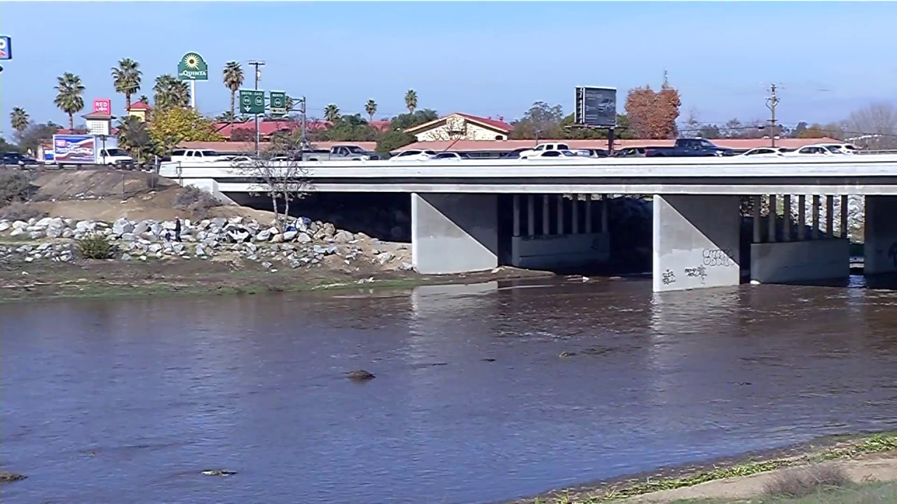
Kern River through Bakersfield in 2011, a relatively good water year.
Kern River through Bakersfield in October 2015, the worst year of the recent drought and the driest year in 2,000 years for the Kern, according to tree rings.
ALMOST DRY
So here’s how 20,000 Bakersfield residents were nearly left high and dry in summer of 2015.
The Kern River ran at a historically low 12.3 percent of normal. So low that Bakersfield’s rights to the river dried up.
That doesn’t mean the city ran out of water since it also buys state water and has ample groundwater.
The problem for those 20,000 residents is that the city sells river water to California Water Service Co. for use in its northeast and northwest treatment plants.
The plants were built to take water straight off the river, as in the case of the northeast plant, or have it delivered via the Beardsley Canal, as the northwest plant does.
So, when the city’s river rights stopped, Cal Water could see it was headed for trouble.
The only entity getting any river water was Kern Delta Water District. And even its supply was only a dribble.
“The river almost went dry last year,” said Mark Mulkay, Kern Delta’s general manager
But it agreed to give Cal Water part of its river supply in a four-way swap.
Kern Delta gave Cal Water water, then pumped a like amount to deliver to its farmers. The Kern County Water Agency’s Improvement District 4 pumped water that was previously banked by Cal Water and ran it to the California Aqueduct on Kern Delta’s behalf to repay Metropolitan Water District, which needed its stored water back from Kern Delta.
“Without this program the northeast plant would have stopped,” Mulkay said. “I don’t think residents understood how close they came to having no water.”
Some observers raised an eyebrow at that, saying the city had an obligation to be much more upfront with residents served by those treatment plants.
I agree.
Either way, I note the city has taken last summer’s lessons to heart.
The council voted on Wednesday to spend $3.5 million to bring a handful of old, inactive wells back online as an back up water source to “keep pressure in the system.”
The city took that step because the Kern County Water Agency said it could no longer guarantee the city extra water on a short-term agreement.
The city insists none of this is “emergency water,” that there is no risk of the city going dry.
Hmmm. I’m sure everyone thought that before last summer, too.
The Kern River flowing through the heart of Bakersfield. The river is the city’s main recharge for groundwater, which is its primary source of drinking water.
HOW WATER DEMAND IS MET
This information is contained in the Urban Water Management Plans for the City of Bakersfield and Cal Water systems.
The most recent plans were done in 2010 and 2011, respectively. The state will require updated plans this year.
All numbers are annual averages; afy stands for acre-feet per year.
Cal Water
14,000 afy of state water is bought from Kern County Water Agency’s Improvement District 4 (ID4)
19,000 afy is Kern River water bought from the City of Bakersfield
44,000 afy is pumped groundwater
Total: 77,000 afy
Bakersfield
6,500 afy is state water bought via ID4
38,000 afy is pumped groundwater
Total: 44,500 afy
Both agencies also bank water in wet years
QUOTES
“Everyone can no longer look at groundwater like a free checkbook. They better account for it.”
— Peter Brostrom, with the water use and efficiency branch of the California Department of Water Resources about how new state law will affect groundwater use
“The housing market is probably more in balance today than it has been for 10 years. There’s not a shortage but not an oversupply either.”
— Gary Crabtree, a Bakersfield appraiser who produces a monthly real estate report
“Even if all those homes are built to current (water conservation) standards, that’s still new water. And the rest of us have to cut back 32 or 36 percent? Where’s the water for those new homes coming from?”
— Gordon Nipp, Kern-Kaweah chapter of the Sierra Club
“Less water is used for housing than farming. So if you’re taking ag out of production for houses, it’s better for the basin. But it feels like it doesn’t matter what homeowners do to save water if we continue exporting water out of the basin.”
— Bryan Batey, local developer
“Cumulative water use (by new developments) may come up but we’re not talking about it now.”
— Scott Thayer, Castle & Cooke vice president of operations and development
“The driest year on record occurred in 1961, with a total Kern River runoff of 19 percent of average.”
— Bakersfield’s 2010 Urban Water Management Plan. The river ran at 12.3 percent of normal in 2015.
The Community Reading Project in Bakersfield pairs reading coaches with struggling readers for 15 minutes per day. Each volunteer commits to one hour a week, helping four kids each visit. The benefits have been astounding, helping struggling readers increase by one to two grade levels in just six months.